
Situated in the eastern United States, the Appalachian Trail has earned a reputation as one of the best scenic trails on the planet. The trail measures 2,193 miles (3529km) and remains the world’s longest hiking-only footpath. In total, the Appalachian Trail courses through 14 states east of the Mississippi River for one epic journey. If you’re one of the daring hikers who wants to go thru hiking, you’ll trek through the following states: Georgia, North Carolina, Tennessee, Virginia, West Virginia, Maryland, Pennsylvania, New Jersey, New York, Connecticut, Massachusetts, Vermont, New Hampshire, and Maine. You’ll climb some of the tallest peaks within the mountain range and traverse through lush valleys and forests.
According to the Appalachian Conservancy, 3 million nature lovers visit the trail, and 3,000 explorers try to complete the entire footpath. The southern terminus is located at Springer Mountain, Georgia and its northern terminus is Maine’s Mount Katahdin. For our post, we’re going to focus on, section hikes, that you can finish within days. Going from south to north, we’ll rank 10 of our favourite section hikes when you’re unable to complete a thru-hike. Regardless of what region you’re located, there will be an exciting hike near you to explore this American legend.
Hiking Essentials
Before you venture onto the Appalachian Trail, it’s imperative to ensure you’re prepared to face the elements. Whether you’re planning a day hike or multi-day adventure, you should learn about the vital tools you need on the trail. You may need to adjust based on your specific itinerary, but here are the basics to include on your backpacking list.
- Durable Hiking Backpack
- Dress in layers of moisture-wicking material
- Hiking boots (ideally waterproof)
- Map or compass (iPhones won’t always save you)
- Food/Snacks
- Water & filterable water bottle
- First-Aid Kit
- Knife
- Multi-Tool Kit
- Waterproof Tent (if camping)
- Emergency Shelter
- Flashlight or Headlamp
- Batteries
- Sunscreen & Sunglasses
- Fire-Starting Tools (if camping)
- DEET (or comparable bug repellent)
- Change of clothes
- Emergency snacks
You can include additional items, but these are the essentials you’ll need for any adventure in the wilderness. It’s crucial to tailor your hiking supplies to the type of expedition you’re planning. Take into consideration the trail length, number of days you’re hiking, and the expected weather forecast for the area.
10 Best Appalachian Trail Section Hikes
Springer Mountain to North Carolina Border | Newfound Gap to Fontana Lake | Lemon Gap to Max Patch | Three Ridges Loop via Mau-Har Trail | Mount Minsi | Anthony’s Nose | Salisbury to Jug End Road | Stratton Mountain via Long Trail | Northern Presidentials | 100 Mile Wilderness |
1. Springer Mountain to North Carolina Border
- Length: 73.2 miles (117,8km)
- Route Type: Point to Point
- Difficulty: Hard
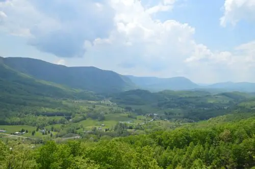
Starting near the mountain town of Blue Ridge, Georgia, this point to point section of the Appalachian Trail courses through the North Georgia wilderness. Springer Mountain is the starting location for AT thru-hikers beginning from the southern terminus of the trail. This makes the trailhead quite busy with backpackers setting out for their adventure. Depending on your speed and endurance, expect to hike around 4-8 days before reaching the North Carolina border.
You’ll tackle about 20,000 feet of elevation gain and traverse through the pristine forests that dot North Georgia. Shelters with primitive bathroom facilities and potable water are spaced about a day’s hike apart. Although there’s a parking lot on Forest Service Road 42 close to the trailhead, many hikers choose to start in nearby Amicalola Falls State Park. The park’s namesake and the main attraction are the 729 ft Amicalola Falls, Georgia’s highest waterfall. Adding this 8-mile hike through the park to Springer Mountain gives you amazing views of the third-highest cascading waterfall east of the Mississippi River.
After soaking up the beauty of Amicalola Falls and reaching Springer Mountain, continue your journey through dense foliage, trickling streams, and breathtaking vistas. This section of the Appalachian Trail is easiest to manage during the spring and fall. The heat and humidity of summer can be unbearable, and there’s a possibility of snow in the winter. Watch out for potentially dangerous wildlife such as black bears and snakes.

2. Appalachian Trail: Newfound Gap to Fontana Lake (Tennessee & North Carolina)
- Length: 38.3 miles (61,6km)
- Route Type: Point to Point
- Difficulty: Hard
This section of the Appalachian Trail cuts through the heart of the Great Smoky Mountains and unveils a wildlife wonderland. The old-growth forest has an enormous population of deer, black bears, elk coyotes, groundhogs, and other endearing creatures. Overall, the habitat nurtures over 60 mammal species, 200 types of birds, and roughly 80 reptiles and amphibians. Here is some info on other Smoky Mountain trails if you don’t feel up to a complete section hike.
When hiking south to north, the multi-day trek includes some of the Appalachian Trail’s steepest climbs and highest peaks. You can always refer to the Appalachian Trail Conservancy for frequent updates inside Great Smoky Mountains National Park. The backcountry is brutal at times, but rewards with life-changing views of the Smokies. Don’t miss the opportunity to reach the top of Clingman’s Dome, the highest point on the Appalachian Trail. The horizon stretches for miles as you gaze over this majestic biodiversity hotspot.

3. Appalachian Trail: Lemon Gap to Max Patch
- Length: 9.7 miles (15,6km)
- Route Type: Out & Back
- Difficulty: Moderate
Max Patch Mountain attracts both section hikers and backpackers for its sensational vistas of the surrounding peaks. The grassy summit enchants visitors with blooming wildflowers and beautiful foliage in all directions. Having a picnic at Max Patch is magical as you sit eye-level with the lingering clouds on the horizon. The sun-drenched mountaintop has earned huge popularity among hikers and finding serenity can be difficult. Sunset is another glorious time to relax in the meadows and watch the sun fade beneath the mountain range.
Hiking to Max Patch via Lemon Gap lets you avoid the worst crowds without bypassing the gorgeous scenery. You’ll wander through Pisgah National Forest and find the solitude that the summit often lacks. The trail courses around creeks and grassy fields present 360° forested mountain views. Lacking the steeper climbs of other section hikes, Max Patch is attainable for most intermediate trekkers. If you’re backpacking the Appalachian Trail, the section has plenty of camping spots and water refill stations.

4. Three Ridges Loop via Appalachian Trail and Mau-Har Trail
- Length: 14.6 miles (23,5km)
- Route Type: Loop
- Difficulty: Hard
Situated in Virginia’s George Washington National Forest, the Three Ridges Loop is one of the state’s beloved backpacking circuits. The strenuous loop presents incredible mountain vistas, cascading waterfalls, and swimming holes. While you’ll gain several thousand feet of elevation in either direction, it’s recommended to hike clockwise. The inclines are steeper when trekking counter-clockwise, and you’ll have better views of the waterfalls on the Mau-Har Trail. You’ll have a vantage of the cascades in front of you instead of having to look backwards.
Follow the Appalachian Trail from Reeds Gap to the stunning overlooks at Bee Mountain and Hanging Rock. Three Ridges is the highlight of the AT section of the loop with an elevation of nearly 4,000 feet. The 360° views from the rocky outcrop offer heart-racing images of the forested valleys cutting through the landscape. If you trek the Mau-Har Trail section in the spring, the area will be blanketed by blooming fields of wildflowers. Make sure to bring your swimming gear once at Campbell Creek to cool off inside the pools.
Campsites and shelters are available near the AT trailhead and throughout the circuit for backpackers. If you drive to the loop, the parking area near Reeds Gap can often get congested on weekends. The rugged terrain has many slippery rocks, and it’s important to wear hiking boots with solid traction. If you’re short on water, there is a spring between the Three Ridges Overlook and Harper’s Creek Shelter. The natural water source may not be available year-round, and you should adequately prepare for the long hike.
5. Mount Minsi via Appalachian Trail (Pennsylvania & New Jersey)
- Length: 5.0 miles (8km)
- Route Type: Loop
- Difficulty: Moderate
Located near the Pennsylvania-New Jersey border, Mount Minsi gives you fantastic views of the Delaware Water Gap. The loop makes just over 1,000 feet of elevation gain and quickly reaches the summit of Mount Minsi. Waterproof hiking boots will come in handy on this hike, and you should be cautious around rocky areas. Consider bringing trekking poles for added stability when climbing over boulders scattered on the trail. The plant life and greenery come to life during spring, and you’ll spot blooming wildflowers around you.
You’ll cross several streams on your ascent, and sections of the trail often become muddy after rainy days. Before reaching the Mount Minsi summit, you’ll have a stunning view of the peak standing opposite of the taller Mount Tammany. Standing on the clifftops provides a glorious photo of the Delaware River coursing through the landscape.
Just past Eureka Creek, an unmarked section of the trail leads to a heart-racing panorama of the Delaware Gap. This viewpoint confuses many hikers since it’s often thought to be a continuation of the path. However, you must retrace your steps to find the stone steps that lead back to the Appalachian Trail. After you reach the near 1,500 ft summit, you can wander unmarked paths for more unbelievable vistas of the Delaware River.
6. Anthony’s Nose, Appalachian Trail, and Camp Smith (New York)
- Length: 7.6 miles (12,3km)
- Route Type: Out & Back
- Difficulty: Hard
This stretch of the Appalachian Trail is among the more challenging section hikes in New York. As you climb along the Hudson River, take in the extraordinary views of Bear Mountain. There are many NYC day hikers on weekends, and parking is often crowded at the trailhead. The trail makes nearly 2,500 feet of elevation gain and ascends stone steps to the highest point. Its trodden path is well marked, and you shouldn’t have a difficult time navigating the trail.
The panoramic views of the Hudson River and surrounding foliage become more spectacular the higher you climb. You’ll notice several little footpaths from the main path, but the views open up around the rock faces. After conquering the steep ascent, don’t miss the breathtaking photo of Bear Mountain Bridge stretching across the Hudson River. When the bridge was constructed in 1924, it was the world’s longest bridge at the time. Surrounded by the eye-popping colours of the Hudson River Highlands, you won’t regret this exhilarating day hike.

7. Appalachian Trail: Salisbury to Jug End Road (Connecticut & Massachusetts)
- Length: 15.6 miles (25,1km)
- Route Type: Point to Point
- Difficulty: Hard
While thru-hiking the Appalachian Trail, this rugged point to point section presents incredible New England vistas. Coursing through Connecticut and Massachusetts, the trail features beautiful foliage and trickling streams. If you go backpacking here during fall, the radiant colours will take your breath away. The steady climb eclipses 4,000 feet of elevation and reaches Bear Mountain, Connecticut’s tallest peak. Standing from the rocky ledge provides a front-row seat to the adjacent forests and waterways. Once you venture into Massachusetts, the trail tackles several notable rocky peaks in the area.
The climb has several steep sections and fallen leaves often present tripping hazards on your section hike. You’ll trek along the ridgeline parts of the trail and have plenty of chances to snap amazing photos. Deep within the forest, the cascading streams form enchanting waterfalls near the path. There might be spots for a refreshing swim but always use caution before dipping your feet in the water. Unless you’re determined to complete this section in one day, camping is recommended for hikers. You’ll encounter challenging ascents and need rock scrambling skills to tackle summits like Mount Everett.

8. Stratton Mountain via Long Trail (Vermont)
- Length: 7.6 miles (12,2km)
- Route Type: Out & Back
- Difficulty: Moderate
Vermont’s Stratton Mountain inspired Appalachian Trail founder Benton MacKaye to create this storied hiking route. When you admire the glorious views from the summit, it’s easy to connect with his heartfelt passion for nature. The gradual ascent to the fabled peak shows off peaceful streams, beautiful wildflowers, and famous Vermont greenery. Stratton Mountain features one of Vermont’s most popular ski lifts and regularly transports visitors to the peak. For day hikers, the path winds through the forest with some rocky and muddy obstacles along the way.
Near the summit, the fire tower offers the chance to reach higher elevation for awe-inspiring 360° views of the Green Mountains. If you’re brave enough to climb the tower, you’ll truly get the sense of MacKaye’s exhilaration decades ago. The lookout often gets hectic with day hikers and thru-hikers, so mid-week is advised to avoid crowds. Unless you’re pressed for time, a detour to Stratton Pond lets you swim in one of Vermont’s surreal watering holes.
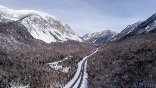
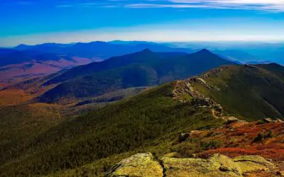
9. Northern Presidentials via Appalachian Trail (New Hampshire)
- Length: 14.3 miles (23km)
- Route Type: Loop
- Difficulty: Hard
New Hampshire presents some of the most challenging terrains on the Appalachian Trail but rewards you with jaw-dropping vistas. For thru-hikers, the long days of trekking through New Hampshire’s White Mountain National Forest can be a struggle. The Presidential Range has incredibly rugged terrain and several of New England’s highest peaks. Hiking along the ridgeline is brutal, but the granite peak views are some of the Appalachian Trail’s most majestic.
The Northern Presidential summits include Jefferson, Adams, and Madison, and nearby Mount Washington is the rooftop of New England. Your hike begins near the base of Mount Washington and makes a rapid ascent early on the trail. If you venture into Tuckerman’s Ravine, know that you’ll need a permit to camp. In total, the loop makes well over 5,000 feet of elevation gain and pushes you to the climbing limits. Trekking poles are handy tools on the Northern Presidentials due to the constant rocky terrain. You’ll notice blankets of snow covering the mountain peaks during cooler months, but summer brings magical cascades flowing down the rugged slopes. The weather in the Presidential Range is often unpredictable, and you should frequently survey the local forecast.
10. 100 Mile Wilderness (Maine)
- Length: 99.1 miles (159,5km)
- Route Type: Point to Point
- Difficulty: Hard
Wandering through the rugged interior of Maine, the 100 Mile Wilderness is about as remote as it gets on the Appalachian Trail. The route is pure, untouched nature and presents a sensational finale for the south to north thru-hikes. You’ll tackle immense geographic diversity that includes rocky ridges, wetlands, natural lakes, and cascading waterfalls. It’s essential to have the proper sleeping bag and hiking equipment since the intense route takes over a week. Novice trekkers shouldn’t dare attempt this northerly section of the Appalachian Trail due to its challenges.
For thru-hikers, it’s difficult to judge the ideal time to embark on this journey for several reasons. Early summer can be treacherous due to pesky black flies, and tourists pack the trail by August. However, don’t wait too deep into the fall since Maine gets dreadfully cold and rainy. If you’re solely hiking the 100 Mile Wilderness, July is your best option for a satisfying adventure. You’ll avoid the worst of the flies, tourists, and eager thru-hikers completing their mission. The moment you catch glimpses of deep-blue lakes, bogs, and rushing streams, you’ll be thoroughly entrenched in this epic American hike.
Are you ready to set out on one of these Appalachian trail section hikes? Let me know in the comments below.

Find out how to quit your job, travel the world, and transform your life
Hey I'm Chantell

I quit my job to travel in 2014 and it's one of the best decisions I've ever made. I know first hand how hard it can be to get everything in place in order to be able to travel, to know what to pack and where to go, let alone how best to go about your travels once on the road. Here I share everything I've learnt so far so you don't have to learn through as much "trial and error" as I did...Read more
My Books

Like it? Pin it ?


Related Posts

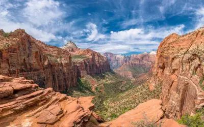
The 13 Best Hikes in Zion National Park
Utah has unbelievable natural scenery, and it’s one of my favorite places to hike in the United States. There’s no shortage of incredible trails in this geologic wonderland. From the hoodoo amphitheatre of Bryce Canyon National Park to the sandstone arches of Arches...
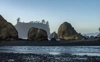
Your Ultimate Guide to the Best Hikes in Olympic National Park
Far away from the red-rock cliffs of Zion National Park and sandstone arches of Arches National Park, Washington’s Olympic National Park feels like a different universe. Its temperate rainforests are unlike anything I’ve ever seen in America, and its rugged coastline...

Top 10 Best Hikes in Arches National Park
If you’re a geology nerd, Utah is the best state in America you could possibly visit. From the massive sandstone cliffs and slot canyons of Zion National Park to the hoodoos of Canyonlands National Park, Utah astounds with its geologic beauty. And for hikers,...
The 15 Best Hikes in Utah
No doubt Utah is one of my favorite states in America. Its wild and remote landscapes and hiking is the best way to explore its diverse terrain. With red-rock cliffs, snow-capped peaks, arid deserts, cascading waterfalls, and slot canyons, Utah’s scenery is impossible...

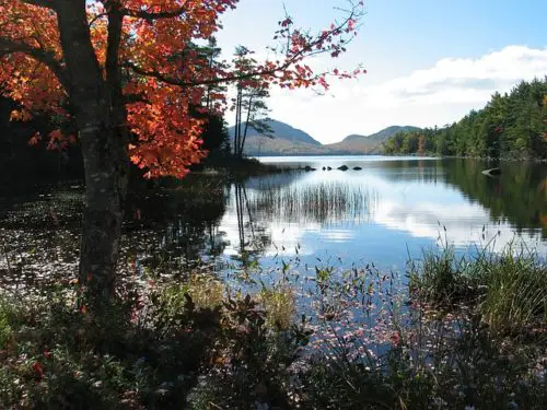
15 Best Things to do in Acadia National Park
When my New England road trip brought me to Maine, Acadia National Park, one of many beautiful National parks on the east coast. Acadia definitely topped my list of places to see in Maine. I heard so much about the majestic beauty of Maine’s rocky coastline and Acadia...
10 Best Hikes in New Hampshire
New Hampshire may be my favorite New England state for epic hiking trails. The White Mountains are a stunning range and contain some of the region’s most exhilarating treks. This is where you’ll find New England’s tallest peak and adventures that will push you to the...

0 Comments